Kelly Stand Loop: An "Epic" Tandem Ride
The term "epic" is vastly overused when describing athletic activities. You can look up the definitions of the word yourself, but if you will permit me to redefine the term to mean a ride that you will remember in detail the rest of your life, then the loop Jeanne and I did on August 20th certainly qualifies.
I had spotted Kelly Stand Road on a map years ago and quickly decided that it was one that I wanted to ride, sometime. I was taken by its remoteness and a couple years ago, I was traveling through the area with a suitable bike in the car and decided to try it. I parked in Arlington and when I reached the start of the road, I noticed with dismay that it was a construction zone. The road had been largely washed out in Hurricane Irene and its rebuild was one of the last of the storm reconstruction projects in Vermont. In fact, the state had planned to simply abandon the road, due the extent of the damage, but locals lobbied their legislators until they found the money to reconstruct it. I forged ahead, past the signs warning me not to, and threaded my way past a number of very large excavators, making it most of the way through before a foreman stopped me. Since it was far shorter to continue on the road, he let me go on, with an admonition to not come back and to not try it again. No problem there, but I think my focus on the construction itself distracted me from the grade and left me with a sense that it was easier that it actually was.
 |
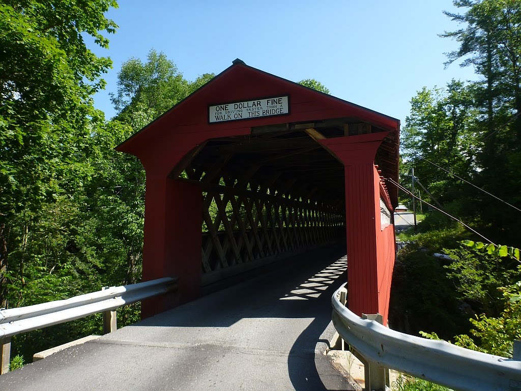
| Chiselville Covered Bridge |
I've long wanted to go back and ride this scenic road on a tandem, so I eventually talked Jeanne into it and we headed down to Manchester to start the ride from there. The stretch from Manchester to Arlington is quite nice, with pleasant roads that parallel the busier US-7. There was only one significant climb and we were rewarded with a ride through the Chiselville covered bridge, near the end of the descent. The name comes from an early mill at this location that was renown for its associated iron works that made outstanding--you guessed it--chisels.
We noticed as soon as we turned onto Kelly Stand Rd that it had been recently graded. We were riding a tandem with 38mm tires, so we had the right rubber for it, but there were a few places where the grade was steep and the surface loose enough that we had barely enough traction to maintain forward momentum. There's a big difference between riding smooth, hard packed dirt and freshly graded gravel, especially of the type that has only recently been laid down. The material contained a lot of sand and none of the clay that tends to work its way up through over decades of use and which can provide a surface that sometimes rivals asphalt. There was a huge difference once we had completed the several miles of newly rebuilt road and were on the section above the washout, which was relatively smooth, in spite of the grading.
 |
| Kelly Stand Rd |
We were about half way up the long climb when I realized I was soaked with sweat. Near the top, Jeanne called me on the fact that I had said it was a long, but easy climb, with only a few steeper pulls. Her GPS had revealed the truth--multiple 18% climbs, extended grades of 13% - 16% and an elevation of 2800' at the top, for an almost unbroken 2100' climb, much of it on some pretty loose and bumpy gravel. This rivals many of Vermont's storied "gaps." Including a couple short breaks on the climb, it had taken us 2 1/2 hours to cover less than 21 miles. On Kelly Stand Rd, we had climbed 1900' in just over eight miles of almost unbroken ascent. Suffice to say, we were plenty glad to reach the top.
 |
| Daniel Webster Monument |
Just before the end of Kelly Stand Rd, where it turns to pavement and becomes the Stratton-Arlington Rd, is a monument that I have been trying to locate for years. At this location, in the summer of 1840, Daniel Webster came to speak, over the course of two days, to an estimated 15,000 people on behalf of the candidacy of William Harrison for president. This event has amazed me since I learned about it, as Kelly Stand was little more than a logging camp at that time (it's uninhabited, now), with the only business being a single, small hotel on the stage line. There was no significant population in the area, yet Webster was such a respected figure that his presence drew a gigantic crowd for the time, with people traveling many miles via horse and buggy to hear him. Political speeches, like sermons in those days, could run many hours but people didn't have the entertainment options that we now have, so they were willing to go through the hardship of a long trek into the wilderness for such an event. To assemble 15,000 people, many of them would have had to travel quite a distance to get there! I think it reflects the level of orator than Webster must have been. Apparently, it was to good effect, as all the counties surrounding the area went for Harrison in the election, some of them by fairly small margins. History buffs will recall that Harrison's term only lasted a month, as he caught a bad cold after giving a long inaugural address outdoors in bad conditions and died, leaving his running mate, Tyler, to complete his term. Today, this monument in a small clearing marks where the event took place.
We were rewarded by an extended, and in some places high speed, winding nine-mile descent to Wardsboro and VT-100. Very little traffic and mostly smooth roads made it quite fun. Then it was another nine miles heading downhill to the intersection with VT-30. After climbing that section so many times during the 100/200, it was nice to be heading the opposite direction. We had coasted most of 18 miles! From there, it was an easy climb up to Jamaica where we took a much needed break. Jeanne's legs started really hurting a couple miles before, leaving us a bit concerned as there was no way to shortcut the ride, but the break, and a chocolate creemee, did wonders, and soon we were on our way again.
I had long wanted to ride some of the West River Rail Trail, and had worked this into the route. There's a great video at
https://www.youtube.com/watch?v=02t9LlbzB78 that describes the trail and shows some of its route. The railroad had run from 1879 until a number of sections were destroyed in the Great Flood of 1927, and it never recovered, becoming fully abandoned in 1936, leaving very little of the infrastructure intact, today. The rail trail is a fairly recent construct, and we were traveling the "upper section," which is bisected by the Ball Mountain Reservoir, which now covers a long section of the old railroad bed. It was this interruption which put the ride over the threshold that I believe qualifies it as "epic."
 |
| Former RR bridge in Jamaica, VT |
The first evidence of the defunct railroad that we encountered was this bridge, which is now used to access the Jamaica State Park. Its placard shows that it was built in 1926, leaving it in use as a RR bridge for only a year. Not wanting to pay the park fee just to ride through on the rail trail, we followed the old rail bed around the gate, and threaded through the campsites until we picked up the trail on the other side.
 |
| West River Rail Trail |
The rail trail in this area is quite nice, but it gradually deteriorates and eventually leaves the old RR bed and becomes more of a trail. There were a couple places where we needed to dismount and push, until a clearing presented us with the wall of stone that is the Ball Mountain Dam. I had only hinted of this to Jeanne, so it was quite a shock to her to learn that we needed to get to the top of it. A steep trail led us to the series of switchbacks that climbed the face of the dam. Although a young couple successfully rode their mountain bikes down it, there was no way we were going to be able to get around the switchbacks with the tandem, so we resorted to pushing the bike to the top.
 |
| Ball Mountain Dam |
 |
| Top of Ball Mountain Dam |
 |
| Aerial View |
 |
| Posing on the dam |
 |
| Jeanne poses in front of the reservoir |
 |
| It would take a lot of water to raise the level to the spillway |
 |
| View of the dam from the west side |
After a false start, we located the trail on the other side. Since the RR bed is somewhere under the reservoir, a hiking trail travels 2 1/2 miles along the edge to link up to the point where the former railroad reappears. Though parts are rideable, and would be more so on a mountain bike, there are a number of sections that were quite tough to get through with a tandem! I was glad that our bike is well-nicked up and thus didn't feel bad about the many rocks it contacted on our way through.
 |
| Stonework on the trail around the reservoir |
 |
| It was worth the trek just to cross this stone bridge in front of the waterfall. |
 |
Jeanne is laughing because she knows it's going to be
my job to carry the bike up this section of the trail. |
We came out on the backside of a campground. After bouncing over all kinds of rough surfaces and trails, I hit a portable speed bump that had been laid across the pavement. I was taking advantage of the smooth asphalt to get to my water bottle and didn't see it until an instant before we hit. The stupid thing was at least 4" tall and the resulting whack left us with a blip in the front rim. I was some peeved that there were no pavement markings warning of this obstacle.
We took another break in Londonderry, and Jeanne was none too happy with the fact that she could see the steep climb on VT-11 that we were going to have to take. We pass by this spot on the 100/200, and I am always glad that our route veers off to the left when we reach this spot, as VT-11 looms like a wall in front of you. That was not going to be the case, today. After downing a cold drink and a couple energy bars, we were back on the bike, passing the sign noting it is eight miles to the Bromley Mountain ski area. This is not a continual climb, but one of those rolling ones. Although we were glad that it was actually only a bit over seven miles to the top, we climbed 1150' to make just 900' of vertical gain. Although I knew what to expect, Jeanne was pleasantly surprised that it was entirely downhill for the last 6.3 miles, with extended 9% grades, making for a fine and fun end to the ride. We earned it!
I highly doubt that we'll be doing this section of the White River Rail Trail again on the tandem. Jeanne commented that her sentiment was the same as that expressed by most riders when they reach the top of the Mt. Snow climb, "Well, I never have to THAT again!" Of course, many do return, so you never know! Still, I'm thinking that we'll just leave it as an "epic" memory, and seek out other challenges in the future.
 |
| I confess that I showed Jeanne a stretched out version of the elevation profile, before the ride. |


2 comments:
Awesome read about an awesome ride!
Will probably take in the Ball Mountain Dam but hiking, not biking.
If you're hiking, be sure to take the side trail to Hamilton Falls.
Post a Comment