Sunday, August 21, 2016

Kelly Stand Loop: An "Epic" Tandem Ride

The term "epic" is vastly overused when describing athletic activities.  You can look up the definitions of the word yourself, but if you will permit me to redefine the term to mean a ride that you will remember in detail the rest of your life, then the loop Jeanne and I did on August 20th certainly qualifies.

I had spotted Kelly Stand Road on a map years ago and quickly decided that it was one that I wanted to ride, sometime.  I was taken by its remoteness and a couple years ago, I was traveling through the area with a suitable bike in the car and decided to try it.  I parked in Arlington and when I reached the start of the road, I noticed with dismay that it was a construction zone.  The road had been largely washed out in Hurricane Irene and its rebuild was one of the last of the storm reconstruction projects in Vermont.  In fact, the state had planned to simply abandon the road, due the extent of the damage, but locals lobbied their legislators until they found the money to reconstruct it.  I forged ahead, past the signs warning me not to, and threaded my way past a number of very large excavators, making it most of the way through before a foreman stopped me.  Since it was far shorter to continue on the road, he let me go on, with an admonition to not come back and to not try it again.  No problem there, but I think my focus on the construction itself distracted me from the grade and left me with a sense that it was easier that it actually was.

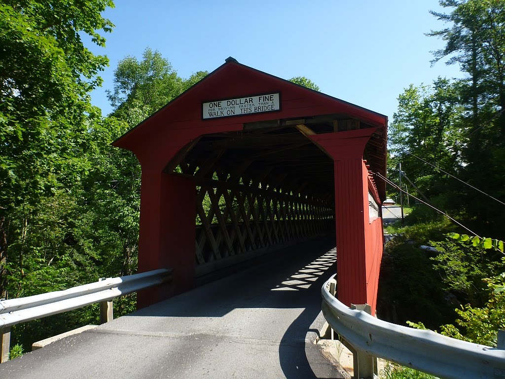
Chiselville Covered Bridge
I've long wanted to go back and ride this scenic road on a tandem, so I eventually talked Jeanne into it and we headed down to Manchester to start the ride from there.  The stretch from Manchester to Arlington is quite nice, with pleasant roads that parallel the busier US-7.  There was only one significant climb and we were rewarded with a ride through the Chiselville covered bridge, near the end of the descent.  The name comes from an early mill at this location that was renown for its associated iron works that made outstanding--you guessed it--chisels.

We noticed as soon as we turned onto Kelly Stand Rd that it had been recently graded.  We were riding a tandem with 38mm tires, so we had the right rubber for it, but there were a few places where the grade was steep and the surface loose enough that we had barely enough traction to maintain forward momentum.  There's a big difference between riding smooth, hard packed dirt and freshly graded gravel, especially of the type that has only recently been laid down.  The material contained a lot of sand and none of the clay that tends to work its way up through over decades of use and which can provide a surface that sometimes rivals asphalt.  There was a huge difference once we had completed the several miles of newly rebuilt road and were on the section above the washout, which was relatively smooth, in spite of the grading.

Kelly Stand Rd
We were about half way up the long climb when I realized I was soaked with sweat.  Near the top, Jeanne called me on the fact that I had said it was a long, but easy climb, with only a few steeper pulls.  Her GPS had revealed the truth--multiple 18% climbs, extended grades of 13% - 16% and an elevation of 2800' at the top, for an almost unbroken 2100' climb, much of it on some pretty loose and bumpy gravel.  This rivals many of Vermont's storied "gaps." Including a couple short breaks on the climb, it had taken us 2 1/2 hours to cover less than 21 miles.  On Kelly Stand Rd, we had climbed 1900' in just over eight miles of almost unbroken ascent.  Suffice to say, we were plenty glad to reach the top.

Daniel Webster Monument
Just before the end of Kelly Stand Rd, where it turns to pavement and becomes the Stratton-Arlington Rd,  is a monument that I have been trying to locate for years.  At this location, in the summer of 1840, Daniel Webster came to speak, over the course of two days, to an estimated 15,000 people on behalf of the candidacy of William Harrison for president.  This event has amazed me since I learned about it, as Kelly Stand was little more than a logging camp at that time (it's uninhabited, now), with the only business being a single, small hotel on the stage line.  There was no significant population in the area, yet Webster was such a respected figure that his presence drew a gigantic crowd for the time, with people traveling many miles via horse and buggy to hear him.  Political speeches, like sermons in those days, could run many hours but people didn't have the entertainment options that we now have, so they were willing to go through the hardship of a long trek into the wilderness for such an event.  To assemble 15,000 people, many of them would have had to travel quite a distance to get there!  I think it reflects the level of orator than Webster must have been.  Apparently, it was to good effect, as all the counties surrounding the area went for Harrison in the election, some of them by fairly small margins.  History buffs will recall that Harrison's term only lasted a month, as he caught a bad cold after giving a long inaugural address outdoors in bad conditions and died, leaving his running mate, Tyler, to complete his term.  Today, this monument in a small clearing marks where the event took place.

We were rewarded by an extended, and in some places high speed, winding nine-mile descent to Wardsboro and VT-100.  Very little traffic and mostly smooth roads made it quite fun.  Then it was another nine miles heading downhill to the intersection with VT-30.  After climbing that section so many times during the 100/200, it was nice to be heading the opposite direction.  We had coasted most of 18 miles!  From there, it was an easy climb up to Jamaica where we took a much needed break.  Jeanne's legs started really hurting a couple miles before, leaving us a bit concerned as there was no way to shortcut the ride, but the break, and a chocolate creemee, did wonders, and soon we were on our way again.

I had long wanted to ride some of the West River Rail Trail, and had worked this into the route.  There's a great video at https://www.youtube.com/watch?v=02t9LlbzB78 that describes the trail and shows some of its route.  The railroad had run from 1879 until a number of sections were destroyed in the Great Flood of 1927, and it never recovered, becoming fully abandoned in 1936, leaving very little of the infrastructure intact, today.  The rail trail is a fairly recent construct, and we were traveling the "upper section," which is bisected by the Ball Mountain Reservoir, which now covers a long section of the old railroad bed.  It was this interruption which put the ride over the threshold that I believe qualifies it as "epic."

Former RR bridge in Jamaica, VT
The first evidence of the defunct railroad that we encountered was this bridge, which is now used to access the Jamaica State Park.  Its placard shows that it was built in 1926, leaving it in use as a RR bridge for only a year.  Not wanting to pay the park fee just to ride through on the rail trail, we followed the old rail bed around the gate, and threaded through the campsites until we picked up the trail on the other side.

West River Rail Trail

The rail trail in this area is quite nice, but it gradually deteriorates and eventually leaves the old RR bed and becomes more of a trail.  There were a couple places where we needed to dismount and push, until a clearing presented us with the wall of stone that is the Ball Mountain Dam.  I had only hinted of this to Jeanne, so it was quite a shock to her to learn that we needed to get to the top of it.  A steep trail led us to the series of switchbacks that climbed the face of the dam.  Although a young couple successfully rode their mountain bikes down it, there was no way we were going to be able to get around the switchbacks with the tandem, so we resorted to pushing the bike to the top.


Ball Mountain Dam
Top of Ball Mountain Dam
Aerial View
Posing on the dam
Jeanne poses in front of the reservoir
It would take a lot of water to raise the level to the spillway
View of the dam from the west side


After a false start, we located the trail on the other side.  Since the RR bed is somewhere under the reservoir, a hiking trail travels 2 1/2 miles along the edge to link up to the point where the former railroad reappears.  Though parts are rideable, and would be more so on a mountain bike, there are a number of sections that were quite tough to get through with a tandem!  I was glad that our bike is well-nicked up and thus didn't feel bad about the many rocks it contacted on our way through.

Stonework on the trail around the reservoir
It was worth the trek just to cross this stone bridge in front of the waterfall.
Jeanne is laughing because she knows it's going to be
my job to carry the bike up this section of the trail.

We came out on the backside of a campground.  After bouncing over all kinds of rough surfaces and trails, I hit a portable speed bump that had been laid across the pavement.  I was taking advantage of the smooth asphalt to get to my water bottle and didn't see it until an instant before we hit.  The stupid thing was at least 4" tall and the resulting whack left us with a blip in the front rim.  I was some peeved that there were no pavement markings warning of this obstacle.

We took another break in Londonderry, and Jeanne was none too happy with the fact that she could see the steep climb on VT-11 that we were going to have to take.  We pass by this spot on the 100/200, and I am always glad that our route veers off to the left when we reach this spot, as VT-11 looms like a wall in front of you.  That was not going to be the case, today.  After downing a cold drink and a couple energy bars, we were back on the bike, passing the sign noting it is eight miles to the Bromley Mountain ski area.  This is not a continual climb, but one of those rolling ones.  Although we were glad that it was actually only a bit over seven miles to the top, we climbed 1150' to make just 900' of vertical gain.  Although I knew what to expect, Jeanne was pleasantly surprised that it was entirely downhill for the last 6.3 miles, with extended 9% grades, making for a fine and fun end to the ride.  We earned it!

I highly doubt that we'll be doing this section of the White River Rail Trail again on the tandem.  Jeanne commented that her sentiment was the same as that expressed by most riders when they reach the top of the Mt. Snow climb, "Well, I never have to THAT again!"  Of course, many do return, so you never know!  Still, I'm thinking that we'll just leave it as an "epic" memory, and seek out other challenges in the future.

I confess that I showed Jeanne a stretched out version of the elevation profile, before the ride.

Sunday, August 03, 2014

Binge Climbing

Many young people engage in binge drinking because they want to impress their friends; after all, there's redemption in shared experience.  The drinking masks the decision of when it would be prudent to stop, and many feel that the limitations we attempt to enforce on access to alcohol simply aggravates the problem.  When they finally do obtain the forbidden mead, they tend to engage in excess, leading to unfortunate behavior that encourages the adults to apply more restrictions.  Once one is old enough that buying alcohol is legal, the attraction tends to diminish for most, especially as we begin to recognize the foolishness and negative aspects of it all and so we turn to other things on which to binge, like climbing gnarly roads where no one would drive a car.  Hence, the attraction of the IRR, the Irreverent Road Ride (or, as I prefer, the Irrelevant Road Ride, since some of these roads have outlived their usefulness).  It's a solid, and customizable set of nasty climbs that some use to prepare for the D2R2 and cyclocross season, and others just to slake their climbing addictions.

 The River Rd at 5:30 am

I decided to ride to the start, it being only 15 miles away, as Jonesville was on the return route and that would allow me to complete the ride without any driving.  I left home at 5:15 and arrived at the start in plenty of time to register, even without the half-hour delay in the actual start.  I was impressed seeing that Pamela Blaylock and John Bailey were prepping their tandem for this rugged ride.  They wisely chose to avoid the sections that went over Class 4 roads, but that still left then riding Moretown Mountain, and Roxbury and Middlebury Gaps.  Hats off to this amazing pair!

Only about 20 intrepid riders, few Vermonters
Surprising number of women riding today

First group heading out

The small sub-group that headed out first included the tandem and four other riders, plus myself.  The entire rest of the ride, I only saw two of the riders who started after us.  Only one rider of this group, named Tim, decided to tackle Cobb Hill Rd, the first Class 4 road of the day.  I really think that there should be another classification category for Vermont roads.  Class 4 roads are unmaintained, but those we rode today are also undriveable with anything other than a jacked-up four wheel drive, or an enduro motorcycle.  Class 5 already references ferry routes, so I propose we call these Class 6, which would be right in line with Cat 6 racing--and equally irrelevant.


Tim broke his rear cantilever cable yoke right at the beginning of the rough section of Cobb Hill, leaving him with only a front brake for the rest of the ride.  It didn't slow him down at all.  The camera angle belies the steepness of this climb.

The Mad River in the morning
 
Cobb Hill dropped us onto 100B, one of Vermont's prettiest roads, especially this morning.  We went downhill to pickup Moretown Common Rd, then Hathaway to Moretown Mountain Rd.


We caught up with the rest of the starting group near the top of Moretown Mountain.  John and Pamela were keeping up with the singles on this relentlessly long climb.

The "Blayleys" climbing Devil's Washbowl Rd, and looking really good!
I believe John holds the record for climbing Mt. Washington on a tandem, with a time that beats most singles. They are well known in the northeast randoneuring crowd for their amazing tandem prowess.  Sadly, this was the last I saw of them for the day, though I caught a glimpse of them leaving Roxbury to climb Roxbury Gap.


I couldn't pass up this picture of a comical road sign.  Yes, there is a farm up that dead end road!


After a short break at the Roxbury General Store, where the counter person graciously filled my empty water bottle, I headed up to ride West Hill Rd.  This was substituted on the ride map when the steeper Tracey Hill section became blocked by road construction.  After a good climb up Webster Rd and the Class 3 section of West Hill, the road shifted to its Class 4 status and didn't look too bad.


Soon, it deteriorated further, but still rideable.


Then it became a muddy mess.  Time to portage.  I didn't see any other bike tire tracks, so I was the first, and as it turned out the only rider to tackle this section.  Eventually the road, which doesn't show up on any maps, becomes a Class 3 again, but it was really steep and the descent highlighted the inadequacies of my cantilevers in the braking department, and the superior howling that I have not been able to eliminate from the rear brake.


Braintree Gap is not really all that steep, but it has few sections that are not at least 10-13%.  What makes it a really tough climb is the surface, which transitions gradually from crushed stone to loose, large rocks as you climb.  It's very technical and would be much easier on a mountain bike.   The sweat was pouring off me to the point where it was hard to hold onto the brake hoods and my leather Brooks became absolutely soaked.  This well-maintained cabin is the only building on the road, an amazing 2/3rd the way up the climb, and the road deteriorates further once past it.


Here's a shot of the road surface.  I tried to hold the camera as vertical as possible, so this should give an impression of its steepness.  It never really lets up, and frequent water bars make it even more challenging, but I was able to ride the whole east side, though I did stop a few times to pick some wild raspberries.  I saw tracks from two other bikes that looked fresh, so I was pretty sure that there were a couple other riders ahead of me.


They have been logging the west side (after pulling an unhealthy amount of timber off the eastern slopes over the past few years), which opened up this impressive view.  It also resulted in some significant improvements in the descent from the previous time I rode this, a few years ago.


There are still sections that would stop any standard four wheel drive vehicle that you cared anything about, but the three foot drops are gone.  The descent was so steep and long that my inadequate braking became too much for me and I opted to walk down a few sections when my hands got tired and to save at least some braking for the rest of the day's riding.


This classic old cemetery on North Hollow Rd doesn't look as if any new residents have arrived in over a hundred years.  The stones I read predated the Civil War.  It is surrounded by an old wrought-iron fence and gate.  The route next followed Rose Rd to the very steep Maston Hill descent to VT-100.  Ah, smooth pavement--it made up a bit for the headwind to Hancock.  How is it that one can always seem to get a headwind, traveling opposite directions on either side of this ridge?  A couple of older gentlemen sitting on the porch of the store offered up the sad confirmation of its closing.  Luckily, I had enough water left for Middlebury Gap.  I asked if they had seen any other cyclists head up the Gap and they said that a small group had gone through a half hour earlier, but they didn't know if one of them was a tandem.  I never did find out if most of the riders were in front of me, or still behind.

Middlebury Gap always fools me.  In spite of all the times I've ridden it, the top section always seems to take me from feeling really good about my climbing ability, to realizing why it earns its status as a gap.  Once over, and after shaking out the stones from my shoes yet again, I stopped at Middlebury College's Breadloaf campus to refill water bottles.  I had never done this before, but there were a lot of students there for summer programs and retreats, so I first tried the laundry, but found only machines and no sinks or spigots.  One of the students suggested "The Barn" and I found it setup with large, blue water dispensers that I used to refill both bottles and an extra, quart bottle I was carrying.  No one objected and I needed all of it by the time I was done.


I had always wanted to ride Steam Hill Rd, so I decided to deviate from the route to do so, and get back on dirt a tad earlier.  I went past the Road Closed Ahead signs and eventually came up on a box culvert installation that required a portage.  The construction workers were all taking the day off, and I took advantage of that gushing stream of water coming from the temporary culvert to rinse off some of the accumulated sweat and mud.  Steam Hill Rd does a fair amount of climbing before dropping back down to the Natural Turnpike, and it's not all that steep, but the surface of packed crush stone and sand proved difficult for my tires.  It seemed to require a lot of energy to ride through and challenging to ride at speed on the descent.  Natural Turnpike was a little better, but a far cry from the smooth, hard clay of Vermont's best dirt roads.

A small pond off the Natural Turnpike

 Natural Turnpike was as beautiful and lightly traveled as ever.  Most of the light traffic that travels between Lincoln and Ripton takes the Lincoln Road. perhaps because of the really gnarly section of Natural Turnpike.  As I approached Lincoln, and the houses started appearing again, the views improved as well.


I saw a couple riders looking at a familiar map outside the Lincoln General Store and they turned out to be the guys who left the tracks on Braintree Gap.  I think we were the only three to ride it.  They were both strong climbers and I rode with them up Forge Hill Rd, taken to avoid a bridge replacement on Quaker Street, leaving them at the top of Downingsville Rd when I stopped to switch water bottles.  We had chatted about whether or not to ride the last serious off-road section, with the general sense that, even without the sections of the route that had already been removed for one reason or another, we had all done plenty of climbing for one day.  They also clued me in as to why they hadn't ridden West HIll Rd--it had been recommended that riders skip this section at the pre-ride briefing.  I missed that little detail, to my regret.  In spite of this, I did start up Beane Rd when I got there, but eventually recognized that the route climbed an amazingly steep section I had ridden once before with John Gaydos, only to find it petering out in an overgrown, log-strewn field in the woods.  I decided not to risk it and returned home via Dugway Rd, to avoid the nasty descent on Wes White Hill.

It was 116 miles of riding and over 10,000' of climbing, much of it on truly challenging terrain.  The time is almost irrelevant, but it took me over nine hours of riding.  I learned that I should not ride such challenging climbs on a humid day, and that I should have switched to the Brooks Cambium for so many hours on a soaked saddle.  It might be a good idea to try a different set of wheels without ceramic rims, in hopes of better braking, since I am not in the market for a new bike with disk brakes.

The ride was memorable enough to warrant such a long blog post, but I might as well have just gone and ridden it alone.  I've done most of these roads already, and rode by myself most of the day.  I could have stuck with the rest of the riders, and probably should have, but few people seemed interested in doing the ride as it was created and promoted, turning it into just another two-gap loop, with a bunch of dirt thrown in.  I'm not clear on why there was a $35 registration fee, since almost nothing beyond the map and a couple of bagels was provided, and the ride organization wasn't very tight.  I'm sure there were some expenses associated with pre-riding and marking the route, and I don't want to come across as cheap, but I really like the model we created with the 100/200 and I think we would all benefit from more free, semi-organized rides, so get out there and plan one! 

Like the teenager with a hangover, I'm swearing off binge climbing for awhile, or at least until my butt isn't so sore.

So, where do you want to ride tomorrow?
Sunday, July 27, 2014

Meeting The Man, Keith Lippy

Tuesday, I received a call from Philip.  "Don't you have a Lippy tandem?  I've heard that Keith Lippy is doing the POMG Cross Vermont Tour this week." We do, indeed, have a Lippy that we purchased nine years ago from its original owner and which is the hands-down favorite of the many tandems we have owned.  Later in the day, after spending some time looking at the route they were to take, I got a call from Todd, who was one of the tour leaders, telling me the same thing.  Together, we hatched a plan to surprise Keith with a visit from one of his creations.

After the Thursday Eastern Tandem Rally ride, Jeanne and I drove over to Waitsfield, parking at the school.  We rode the tandem the mile from there to the B&B where the POMG group was staying.  Todd greeted us, then went up to get Keith, giving him a fictitious story about a couple of riders who were having mechanical problems, and couldn't he, with his experience, help them out?  No doubt, Keith was not excited about being tapped to work on his vacation but, being a nice guy, he skipped his shower and came down to see what was going on.  The look on his face when he emerged onto the deck and saw the tandem, in its original paint, was truly priceless.  Soon, his wife Pat joined us and we spent at least a half hour chatting about the bike and Keith's framebuilding history.


Keith quit building frames in the late 1990s to teach high school science.  He's got a few years left before retirement and says that he's leaving the door open to doing some bike work again in retirement, though not on a full commercial scale.  It was obvious that he took a great deal of pride in his work as a framebuilder and that he was an early developer and adopter of a number of innovations that found their way into accepted frame design.  Keith also corrected a number of misconceptions I had received from reading online posts from self-proclaimed "knowledgeable experts."

Keith did, indeed, build some frames and forks for Masi, but he did not master the trade in the Carlsbad shop, as some seem to think.  Once Carlsbad closed, Keith (who had started building his own bikes in San Diego around 1974, near, but not associated with Masi USA) agreed to manufacture for Masi under contract in his own shop.  Without mentioning names on the Masi side, Keith put his own business on hold to do the Masi work, but this proved difficult.  The Masi work came in fits and starts, with unexpected delays in obtaining components and orders that resulted in periods of weeks in which Keith didn't have work.  One cannot take custom orders without the ability to provide delivery dates, so he wasn't making money on the deal, overall.  Add to that delays in receiving payment, and it didn't take Keith too long to throw in the towel on the Masi deal, which still seems to be a thorn in his side.  This would have been around 1977, before Masi setup the Rancho Sante Fe and San Marco operations.

Keith said that our bike has the third generation of his decals (which was likely the last.  The serial number and information I received from the original owner places the frameset around 1987.  It has a number of unusual, custom details (more on those later).  Keith said that he was dissatisfied with the Columbus tandem tubing that was commonly used at the time.  Contrary to what has been stated by some of the aforementioned "experts", Keith did not use custom-drawn tubing from Pacific northwest aerospace suppliers.  Rather, the frame is made from straight gauge chromoly steel, with the oval top tube from Phil Wood, who was custom-drawing these for framebuilders at the time.  Phil had become a supplier for the tandem market, expanding his highly respected hub and bottom bracket offerings with an advanced (if fatally flawed from a design perspective) disk brake.  Keith also wasn't merely experimenting with oval tubes, as some claim, but rather had a design philosophy that followed from an analysis of the stresses on tandems.  He reasoned that the forces acting on the top tube were primarily horizontal, while stresses in the boom tube were torsional.  He felt that the best combination would be an elliptical top tube, and round mid and boom tubes, providing improved stiffness while softening road shock.  At least one other, now famous, tandem builder visited Keith's shop to benefit from his experience, though, having one of this builder's tandems from that era, I can tell you that he missed the recipe for Keith's secret sauce.

Here are some features of our Lippy.

That's the Lippy logo in the fork crown.  Keith said he had the fork blades custom drawn to use a heavier gauge steel and added an insert into the steerer to strengthen the fork in this critical area.  That's the original Dura Ace road headset, which is still in excellent condition.


Note the use of the oval top tube to internally route the rear brake cable.  The Scott Superbrake looks a lot cooler than it works.  Perhaps its lack of performance has more to do with the 25 year-old brake pads than the unique brake design.


Clean brazing on the front dropouts.


The brass head badge is silver brazed directly onto the frame.  It has discolored a bit under the clearcoat, but it's still classy, perhaps only challenged at the time by Bilenky's silver creations on his Sterling tandems.  The Scott Superbrake provides barely enough clearance for 28mm tires.


Here's a full-on shot.  The bike is a tad too large for Jeanne to allow fitting of a shock absorbing stoker seatpost , so we've replaced the rear saddle with a sprung Brooks leather model that has proven quite satisfactory.  The custom fade was done to the customer's specification by Keith, who did his own painting.  No stock colors or limited selections for Lippy customers.


Keith pointed out the large-diameter seat stays he used to stiffen the rear triangle, rather than to add an extra set of stays.  Keith didn't recall fitting any Campagnolo cranksets to his tandems.  These were on it when I got the bike, though I replaced the triple arm with one that was drilled for standard 74mm chainrings, to get a lower gear for our Vermont mountains.  I've always loved their clean, vintage look.


I don't think I ever noticed the rider in the negative image formed by the left side of this decal until Keith pointed it out.  Apparently, we were not the only ones who didn't see this in the graphic.


Note the custom seatpost binder and the points on the seat tubes, custom details that didn't make it onto all his frames, according to Keith.


Rear Brake Bridge Detail


Seat Tube Decal

We really appreciated the opportunity to meet the builder of our favorite tandem.  Keith had mentioned to the other riders on the tour that he had been a builder, but they were not aware that he was one of the legends of American framebuilding until we showed up with the proof of his skill and design genius.  There's a reason why, over 25 years later, people still skip over a hundred high-tech Cannondales, Co-Motions, and  Santanas, to see the Lippy at tandem rallys.  Keith said that, should he return to building in retirement, he will likely stick to singles, even though most of the frames he made were tandems.  Too bad--we told them that, if we could, we would commission him to make one like ours, but custom sized.  We love it!

Climbing the Dirt on a Tandem

The Rodriguez Toucan tandem passed the final road test on a 25-mile ride Friday, so we decided to put it through its paces, selecting a loop of primarily dirt roads, starting in Essex and going up through Fairfield. Many of these roads were unfamiliar, and the elevation graphs indicated that there would be some challenging climbs, but we felt that we were in good enough shape from the Eastern Tandem Rally last week to tackle it as we gamely set off.  I picked up the Toucan last spring, in my ongoing search for a good tandem for the dirt that actually fit.  Sadly, the purchase of a Santana that would have been a fantastic deal fell through, but the Toucan has turned out to be a really nice ride.  It has heavily ovalized top and boom tubes and a mildly ovalized mid-tube.  It was sold as an entry level tandem in 1998, but this was largely due to the component package.  The frame is actually quite nice.  I swapped out the crankset, which was junk, and replaced the drum brake setup with a standard, 8-speed mountain bike wheel.  The 26 x 32 gear seemed a bit too low, but turned out to be a good choice for this ride.  With the stem lengths finally dialed in, it's a quite nice riding bike and the fat, 26" slicks turned out to be perfect for the loose gravel and crushed stone we ran into, which would have stopped road tires.

It was a partially cloudy, 75 degrees when we started, with a very light tailwind, making for perfect riding conditions.  We started out heading up the long, easy climb up Woods Hollow Rd.  There was almost no traffic until we came out on VT-128 for the long descent into Fairfax.  We made the steep climb on Boissoneault Rd, stopping to look at the picturesque falls.  Starting out on the steep climb was a challenge, and we dropped the chain, while shifting into the smallest chainring, so I will need to add a guide to avoid that problem.  We realized that starting out on a steep climb on dirt is easiest when you are in the saddle, so we perfected that technique as we went along.

We continued knocking off the easy climbs on Huntville and Woodward Rds until turning onto paved Buck Hollow and its pleasant descent to South Rd.  There was some disagreement about the wisdom of selecting Ridge Rd for the next turn.  The stoker has decided that certain road names should be avoided.  This first included the obvious "Hill," "Mountain" and "Gap," and was extended to include "Hollow" and, most recently, "Ridge."  I assured Jeanne that this Ridge Rd was downhill in both directions, a concept that was immediately challenged, but since the road wound around with no steep sections visible at the start, there was no immediate mutiny.  True to form, the road soon pitched up to a decent, though not extreme grade, and there was some general grousing about having to do that much climbing on a road with the word "Ridge" in the name, but which had no view.  Eventually, we came out by some farm fields which the GPS seemed to want to send us off through.  This is not all that uncommon on secondary roads, where the databases sometimes keep the road on a route that was altered decades ago.  Soon there seemed to be a serious discrepancy, as the available options led us off the route, both proving to be dead ends.  Closer inspection showed a muddy, hidden, ATV trail as the likely alternative and, with much cajoling and an agreement to walk the bike, we set off through the woods.
"If this doesn't go through, it's all your fault!"
After awhile, the road leveled out a bit and was at least partially rideable.  Before it became an actual road again, it went past a sap collection shed and the sugarer had brought in a number of loads of large, crushed stone, laying it quite deep, apparently as it came off the truck, not bothering to grade it at all.  Surprisingly, we were able to plow through most of it with the fat tires.  We were rewarded with a nice, long descent on Romar and Lapland roads.

We looped around on Lost Nation Rd, to start back on Taylor.  While we had already hit a section that the GPS reported as over 23% (unlikely), Taylor Rd proved to be the most challenging.  It had a two-mile climb, with a short break about half way.  The last mile was the toughest, with an extended section over 15% at the end, approaching 19%, according to the GPS.  It was steep enough that the rear tire was skipping out on the dirt, something we hadn't experienced before on a tandem.  We made it without stopping, not wanting to try starting again on the steep grade, though we certainly thought about it.
View of Mansfield from North Rd
We were rewarded with lots more descending and some really nice views from North Rd.  We wound through Fletcher and then down to the river on Black Mtn. Rd.  After a stop at the store on VT-104, we headed up Sand Hill Rd.  Now, this does include the word "Hill" in the name, but the stoker had been so beaten up by the climbs that there was little more than some light whimpering and general resignation to the abuse ahead.  As it turned out, there was only a single short, if steep pull, before the road leveled out and started descending.  It was actually quite a bit easier than 128 would have been.  There was a long section of deep, very loose gravel, but signs gave us the impression that this was road work in progress.  Could it be that pavement is on its way?  If so, this will become our preferred route back to Westford.

We turned onto Brookside Rd for the easy climb past the Westford School.  Though Jeanne suggested we drop back to 128 and take the easy way back, we stuck to the route, making the steep climb to Woods Hollow, on Phelps, picking up Old Stage Rd and it's sweet descent to Chapin.  Ok, there's a little climb past the golf course, but it's easy, not to mention paved.

This was, perhaps, one of the toughest rides we've ever done.  Lots of loose stuff, plenty of steep climbs, with over 4k'of elevation gain, if the GPS is to be believed.  At 56 miles, it seemed harder than the paved Prouty century we rode a few weeks ago.  Jeanne keeps saying "Never again," (at least for some of these roads) but this attitude is bound to soften a bit, once she is again able to climb the stairs without complaining about her stiff legs.  The bike certainly proved that it is an excellent replacement for our old Santana.  The dirt is calling!

Tuesday, July 15, 2014

Prouty On!

Jeanne and I rode The Prouty for the fifth time last Saturday.  We've always done the full 100, on the tandem, of course.  The start was pleasantly cool, with a light fog, but things warmed up fairly quickly under a clear sky.  As usual, there was a huge number of riders participating, and we ran into a number of people that we know.  The tandem has its own speed, though, so we didn't ride for any appreciable distance with anyone in particular.
Moosilauke Highway
The worse part of such a popular charity ride is that there are almost always people riding slowly up every hill.  Tandems are not known for their hill-climbing prowess, though they descend like rockets, but it's really hard to go as slow as many of these riders.  On a single, you can simply accelerate around the group and then get back to your tempo, but it takes a lot more effort to do this on a tandem.  You need to time things so that you can get completely around the riders while there is a break in the traffic, and it doesn't help when they are going at different speeds.  It would be a lot easier if people would stay to the right, as the Prouty route features lots of wide shoulders, but this is, after all, a social event, so one can understand it if folks want to chat alongside their friends, where possible.
Sue & Dave approaching the bridge to Vermont
We caught up to Sue and Dave on their tandem a bit over half-way through the loop.  They had ridden the 100/200 back in June, the first to ever do so on a tandem!  They are a strong team and it was fun to ride with them, though they were stronger up some of the hills than we.  SAG stops are placed every ten miles or so on the Prouty route, and we were skipping every other one.  Being out of sync with the stops Sue and Dave were using, we were only with them for about 10 miles.  We added our names to those of the others riding for Team Hoss this year, mostly because so many Team Hoss folks have ridden the 100/200 over the past few years.  Team Hoss was the third highest fundraising team this year, raising over $86K.

Connecticut River, south of Wells River
As usual, we picked up a headwind when we headed south in Wells River, but it wasn't nearly as bad as in some previous years.  By the 80-mile mark, we were both pretty cooked and were happy when we passed the steel drum band on the final (and steep) hill, just before the finish.  We finished with an average speed of just over 17 mph, which was significantly slower than last year, but still respectable.  We'll be in good shape for the Eastern Tandem Rally in a couple weeks.

At the post-ride festivities, we loaded up our plates and headed for one of the three huge tents, randomly selecting one of hundreds of tables, where there happened to be two vacant seats.  After a few minutes, I noticed that a person sitting at the other end of the row of tables looked familiar and, sure enough, it was John Painter, along with Phil Surks and his family.  Now, it is a bit odd to randomly end up at the same table as someone you know in an event this large, but it's far stranger when this is exactly what happened two years ago, with the same people, and it's not like we were even sitting in the same place!  It reminded us of last year, where we ran into two friends at the 25-mile SAG stop and they each started introducing us to the other person.  It turns out that the two guys had never met before, and had randomly found themselves riding together and struck up a conversation on the climb to the SAG.  They didn't realize that we knew both of them already--and very few of the thousands of other people there.

We've lost too many friends of ours to cancer and have known far too many others who have contracted one form or another of the disease.  I am reminded of Richard Thompson's verse, "Too many friends of ours, blown off this mountain in the wind."  As we get older and that circle grows, and we realize it could happen to anyone, including us, riding the Prouty becomes more and more a compelling experience.  With our clutch of yellow ribbons bearing the names of some of these folks streaming from the back of our tandem, it's hard not to be reminded that any of them faced much greater obstacles than we did on this little ride on a beautiful summer day, climbing our little hills.  They were the giants.  They climbed mountains.